Bend Oregon Photos- Pilot Butte
Ah, Pilot Butte.... or "The Butte," as we locals like to call it. "I walked the Butte today." "Guess who I saw up on the Butte?" Pilot Butte is an old cinder cone in Bend Oregon, that has now been turned into a state park (although the website http://www.oregonstateparks.org/park_42.php claims the Butte is east of Bend, it is actually just on the east side of Bend...within city limits). There are two trail routes up to the top, which equates to a 2-mile walk (round trip). Once you reach the summit (which offers a rather stunning view of Bend and Central Oregon), there is mountain view finder that will help you find any of the Cascades. It's rewarding workout for all.
Ah, Pilot Butte.... or "The Butte," as we locals like to call it. "I walked the Butte today." "Guess who I saw up on the Butte?" Pilot Butte is an old cinder cone in Bend Oregon, that has now been turned into a state park (although the website http://www.oregonstateparks.org/park_42.php claims the Butte is east of Bend, it is actually just on the east side of Bend...within city limits). There are two trail routes up to the top, which equates to a 2-mile walk (round trip). Once you reach the summit (which offers a rather stunning view of Bend and Central Oregon), there is mountain view finder that will help you find any of the Cascades. It's rewarding workout for all.

The Photo above is an information board at the base of Pilot Butte. It tells about the history of Pilot Butte, and some of the Bend area.
 This photo is taken of the left fork or the paved route. By following this you actually walk away, sort of, then hairpin back to road. This will keep you on the paved portion of the road to the top, rather than the dirt trail.
I took the above photo at the summit of Pilot Butte. Up there, you'll find great views of the surrounding city and mountains. This is a compass and points off to each mountain. It gives the name and some general info.
 This image is on the decent. Rounding the first corner as you leave the viewing area, you met by a spiraling downward road. I thought this old snag was kind of interesting, so I snapped a picture of it.
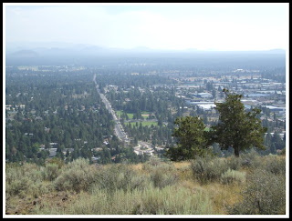 As you round the old snag and walk down a couple feet, if you turn to your left, you can see all the way down 15th Street. It looks off to the South East. You can see by this photo it's kind of a smokey August summer.
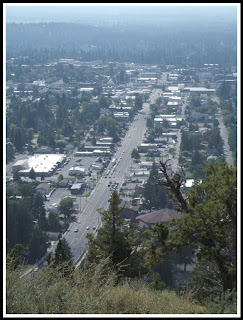
This is kind of the stock photo everyone takes from Pilot Butte. You'll see all kinds of Bend Oregon posters and websites that are of this very image. It looks up Highway 20, to the west.
 This photo is of Pilot Butte Middle School's track. It kind of stick outs against a lot of the Central Oregon landscape. This is just off Neff Road, and one of several middle schools in Bend.
A view down the side of Pilot Butte. You can see the yellow wildflowers (or weeds?) sprouting out of the hill side. Also seen here are natural wooden reinforcements, holding the loose cinder hillside from sliding. My final shot is of Highway 20 Eastward. You can see Smolich Motors, and Hertz in this photo. Follow this Highway East and you'll head toward Prineville, Burns, and Idaho.
No comments:
Post a Comment